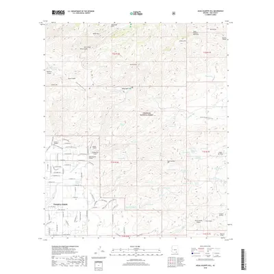
2018 Map of Agua Caliente Hill
USGS Topo · Published 2018About this map
Tanque Verde sits at the southwestern edge of this landscape, where residential streets like E Tanque Verde Rd and E Fort Lowell Rd meet the rising foothills of the Santa Catalina Mountains. The transition from suburban Pima County to the protected wilderness of the Coronado National Forest is sharp, defined by a complex network of canyons and peaks. Significant elevation changes are marked by landmarks such as Agua Caliente Hill and Guthrie Mtn, while the Arizona National Scenic Trail winds through the high country.
Find a feature on this map
110 named features on this map. Tap any name to fly to it.
Don’t see what you’re looking for? This feature index may not catch every label — zoom into the map to look around manually.
Map Details
Editions of this 2018 Agua Caliente Hill Map
This is the sole edition of this map. No revisions or reprints were ever made.
Other maps of this area

1904 · Tucson
USGS Topo · 1:125,000

1905 · Tucson
USGS Topo · 1:125,000

1948 · Tucson
USGS Topo · 1:62,500

1956 · Tucson
USGS Topo · 1:250,000

1957 · Tucson East
USGS Topo · 1:24,000

1957 · Bellota Ranch
USGS Topo · 1:62,500

1957 · Tucson
USGS Topo · 1:62,500

1957 · Rincon Valley
USGS Topo · 1:62,500

1957 · Sabino Canyon
USGS Topo · 1:24,000
1957 · Mount Lemmon
USGS Topo · 1:62,500