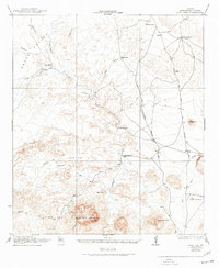
1917 Map of Agua Fria
USGS Topo · Published 1945About this map
Agua Fria Spring emerges at the base of Agua Fria Mountain, serving as a vital water source in this arid Brewster County landscape. Surveyed in 1917, the map captures a network of primitive transportation routes that were essential for regional movement before modern highways. The Old Alpine and Terlingua Road and the Terlingua Trail cross through a terrain defined by desert flats and volcanic peaks, connecting isolated outposts like the Old Stage Stand and Adams Ranch.
Find a feature on this map
34 named features on this map. Tap any name to fly to it.
Don’t see what you’re looking for? This feature index may not catch every label — zoom into the map to look around manually.
Map Details
Editions of this 1917 Agua Fria Map
2 editions found
Other maps of this area

1903 · Chisos Mountains
USGS Topo · 1:125,000

1903 · Terlingua
USGS Topo · 1:125,000

1904 · Terlingua
USGS Topo · 1:125,000

1905 · Chisos Mountains
USGS Topo · 1:125,000

1917 · Agua Fria
USGS Topo · 1:62,500

1917 · Tascotal Mesa
USGS Topo · 1:62,500

1917 · Santiago Peak
USGS Topo · 1:62,500

1917 · Buck Hill
USGS Topo · 1:62,500

1918 · Bone Spring
USGS Topo · 1:125,000

1918 · Buck Hill
USGS Topo · 1:62,500