
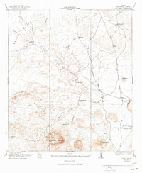
1917 Map of Agua Fria
USGS Topo · Published 1917About this map
Agua Fria Mountain dominates the southern landscape of this 1917 survey, a testament to the Chihuahuan Desert terrain of Brewster County during the early twentieth century. This map, produced in cooperation with the War Department, documents a network of vital transit routes and water sources essential for survival and commerce. The presence of the Old Stage Stand and the distinction between the Old Alpine and Terlingua Road and the newer New Alpine and Terlingua Trail illustrate the evolving infrastructure of the Big Bend region. Settlement is sparse, represented by isolated outposts such as Adams Ranch, Hale Cabin, and Burnt House Camp. Water features like Cheosa Waterhole, Dewees Tank, and various unnamed springs and wells along the Alamo Cesario Creek highlight the critical role of reliable water in this arid environment, while terrain features like Fizzle Flat and Bandera Mesa define the local topography.
Find a feature on this map
37 named features on this map. Tap any name to fly to it.
Don’t see what you’re looking for? This feature index may not catch every label — zoom into the map to look around manually.
Map Details
Editions of this 1917 Agua Fria Map
2 editions found
Other maps of this area

1903 · Chisos Mountains
USGS Topo · 1:125,000

1903 · Terlingua
USGS Topo · 1:125,000

1904 · Terlingua
USGS Topo · 1:125,000

1905 · Chisos Mountains
USGS Topo · 1:125,000

1917 · Tascotal Mesa
USGS Topo · 1:62,500

1917 · Santiago Peak
USGS Topo · 1:62,500

1917 · Buck Hill
USGS Topo · 1:62,500

1918 · Bone Spring
USGS Topo · 1:125,000

1918 · Buck Hill
USGS Topo · 1:62,500

1918 · Santiago Peak
USGS Topo · 1:62,500