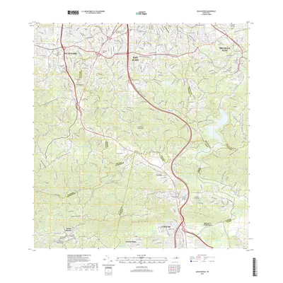
2018 Map of Aguas Buenas
USGS Topo · Published 2018About this map
The northern foothills of the Island of Puerto Rico meet the expanding metropolitan reaches of San Juan in this 2018 survey. The landscape is defined by the steep elevation changes of Altos de la Mesa and Altos de San Luis, where residential development and industrial corridors weave through deep ravines and valleys carved by the Rio Grande de Loiza and the Rio Bairoa. Major transit is dominated by the Autopista Luis A Ferre, which bisects the region and facilitates the suburban growth between Guaynabo, Trujillo Alto, and Caguas. Educational institutions like the Interamerican Univ of Puerto Rico Recinto de Metro and Universidad Pentecostal Mizpa mark the northern urban fringe. Further south, the terrain becomes increasingly complex around the municipality of Aguas Buenas, where smaller settlements like La Liga and Las Carolinas sit atop the ridges. The map also documents numerous modern memorial sites, including the Cementerio Caguas Memorial Park and El Señorial Memorial Park.
Find a feature on this map
60 named features on this map. Tap any name to fly to it.
Don’t see what you’re looking for? This feature index may not catch every label — zoom into the map to look around manually.
Map Details
Editions of this 2018 Aguas Buenas Map
This is the sole edition of this map. No revisions or reprints were ever made.
Other maps of this area

1940 · Carolina
USGS Topo · 1:30,000

1941 · Bayamon
USGS Topo · 1:30,000

1941 · San Juan
USGS Topo · 1:30,000

1941 · Carolina
USGS Topo · 1:30,000

1946 · Aguas Buenas
USGS Topo · 1:30,000

1946 · Comerio
USGS Topo · 1:30,000

1946 · Naranjito
USGS Topo · 1:30,000

1946 · Gurabo
USGS Topo · 1:30,000

1946 · Juncos
USGS Topo · 1:30,000

1946 · Caguas
USGS Topo · 1:30,000