1952 Map of Aguas Buenas
USGS Topo · Published 1953About this map
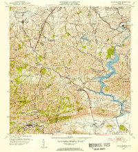
Aguas Buenas sits at the southern edge of this mid-century landscape, a region defined by the complex transition from the urban fringes of San Juan to the interior hills. The 1952 revision captures a network of rural schools and small settlements connected by the primary artery of PR 1, which cuts a path from Guaynabo toward the south. Along the eastern reaches, the Rio Grande de Loiza and the Aljibe las Curias reservoir anchor the local hydrology. Notable landmarks of the era include the Antena de Radio (WAPA) and the Leprocomio medical facility. Educational hubs like the Escuela Segunda Unidad de Rio Cañas and Escuela Mariano Abril serve as focal points for the surrounding barrios. The topography is meticulously detailed, showing the ridge lines of Altos de la Mesa and the winding course of the Rio Bayamon.
Find a feature on this map
83 named features on this map. Tap any name to fly to it.
Don’t see what you’re looking for? This feature index may not catch every label — zoom into the map to look around manually.
Map Details
Editions of this 1952 Aguas Buenas Map
2 editions found

Other maps of this area

1940 · Carolina
USGS Topo · 1:30,000

1941 · Bayamon
USGS Topo · 1:30,000

1941 · San Juan
USGS Topo · 1:30,000

1941 · Carolina
USGS Topo · 1:30,000

1946 · Aguas Buenas
USGS Topo · 1:30,000

1946 · Comerio
USGS Topo · 1:30,000

1946 · Naranjito
USGS Topo · 1:30,000

1946 · Gurabo
USGS Topo · 1:30,000

1946 · Juncos
USGS Topo · 1:30,000

1946 · Caguas
USGS Topo · 1:30,000
Featured Places
- Guaynabo, Guaynabo
- Trujillo Alto, Trujillo Alto
- Aguas Buenas, Aguas Buenas
- Sector Pizarro, Guaynabo
- Sector Pueblo Santo, Guaynabo