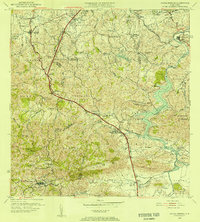
1955 Map of Aguas Buenas
USGS Topo · Published 1956About this map
Aguas Buenas and the surrounding municipalities sit at the heart of this mid-century survey, which details a landscape of expanding settlements and agricultural barrios. The northern reaches of the map show the emerging urban footprints of Guaynabo and Trujillo Alto, while the southern interior remains defined by the winding course of the Río Grande de Loíza and its numerous tributaries like the Río Cañas. Notable infrastructure of the era includes the Aljibe las Curias and several antenna sites such as Antena de Radio (WAPA), signaling the modernization of the island's communications.
Find a feature on this map
82 named features on this map. Tap any name to fly to it.
Don’t see what you’re looking for? This feature index may not catch every label — zoom into the map to look around manually.
Map Details
Editions of this 1955 Aguas Buenas Map
This is the sole edition of this map. No revisions or reprints were ever made.
Other maps of this area

1940 · Carolina
USGS Topo · 1:30,000

1941 · Bayamon
USGS Topo · 1:30,000

1941 · San Juan
USGS Topo · 1:30,000

1941 · Carolina
USGS Topo · 1:30,000

1946 · Aguas Buenas
USGS Topo · 1:30,000

1946 · Comerio
USGS Topo · 1:30,000

1946 · Naranjito
USGS Topo · 1:30,000

1946 · Gurabo
USGS Topo · 1:30,000

1946 · Juncos
USGS Topo · 1:30,000

1946 · Caguas
USGS Topo · 1:30,000