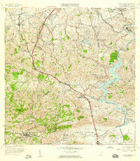
1957 Map of Aguas Buenas
USGS Topo · Published 1959About this map
Aguas Buenas sits at the southwestern edge of this 1957 landscape, serving as a hub for the surrounding mountainous barrios. The terrain is defined by the winding course of the Rio Grande de Loiza and the waters of Lago Loiza, which dominates the eastern half of the map. This era shows a community in transition, balancing agricultural roots with emerging infrastructure, evidenced by landmarks like the Leprosomio near Pueblo Seco and the Planta de Purificacion.
Find a feature on this map
88 named features on this map. Tap any name to fly to it.
Don’t see what you’re looking for? This feature index may not catch every label — zoom into the map to look around manually.
Map Details
Editions of this 1957 Aguas Buenas Map
This is the sole edition of this map. No revisions or reprints were ever made.
Other maps of this area

1940 · Carolina
USGS Topo · 1:30,000

1941 · Bayamon
USGS Topo · 1:30,000

1941 · San Juan
USGS Topo · 1:30,000

1941 · Carolina
USGS Topo · 1:30,000

1946 · Aguas Buenas
USGS Topo · 1:30,000

1946 · Comerio
USGS Topo · 1:30,000

1946 · Naranjito
USGS Topo · 1:30,000

1946 · Gurabo
USGS Topo · 1:30,000

1946 · Juncos
USGS Topo · 1:30,000

1946 · Caguas
USGS Topo · 1:30,000