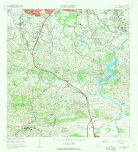
1964 Map of Aguas Buenas
USGS Topo · Published 1966About this map
The boundary of San Juan and Guaynabo passes through a landscape defined by rapid mid-century development and steep tropical terrain. Dense residential clusters like Beverly Hills and Villa Clementina contrast with the rugged interior hills of Cerro Marquesa and Altos de la Mesa. The northern edge is anchored by the urban expansion of Ponce de Leon and Santa Maria, while the southern reaches remain dominated by the agricultural and rural character of Aguas Buenas and Sumidero.
Find a feature on this map
134 named features on this map. Tap any name to fly to it.
Don’t see what you’re looking for? This feature index may not catch every label — zoom into the map to look around manually.
Map Details
Editions of this 1964 Aguas Buenas Map
This is the sole edition of this map. No revisions or reprints were ever made.
Other maps of this area

1940 · Carolina
USGS Topo · 1:30,000

1941 · Bayamon
USGS Topo · 1:30,000

1941 · San Juan
USGS Topo · 1:30,000

1941 · Carolina
USGS Topo · 1:30,000

1946 · Aguas Buenas
USGS Topo · 1:30,000

1946 · Comerio
USGS Topo · 1:30,000

1946 · Naranjito
USGS Topo · 1:30,000

1946 · Gurabo
USGS Topo · 1:30,000

1946 · Juncos
USGS Topo · 1:30,000

1946 · Caguas
USGS Topo · 1:30,000