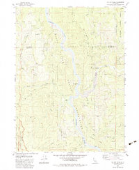
1983 Map of Ah Pah Ridge
USGS Topo · Published 1983About this map
The Klamath River winds through the heart of this North Coast landscape, marking a central corridor where the Hoopa Valley meets several protected wilderness areas. This 1983 survey shows the convergence of the Redwood National Park, Prairie Creek Redwoods State Park, and Six Rivers National Forest. Local history is visible in the presence of McCovey Ranch and Ah Pah Ranch, along with the Blue Creek Lodge (Site) situated near the riverbanks. The terrain is defined by prominent elevations such as Ah Pah Ridge and Starwein Ridge, cut by numerous tributaries including Pecwan Creek, Blue Creek, and the South Fork Ah Pah. Extensive networks of 4wd and private roads suggest the area's ongoing management for timber and outdoor recreation, while borrow pits indicate localized resource extraction during this era.
Find a feature on this map
37 named features on this map. Tap any name to fly to it.
Don’t see what you’re looking for? This feature index may not catch every label — zoom into the map to look around manually.
Map Details
Editions of this 1983 Ah Pah Ridge Map
This is the sole edition of this map. No revisions or reprints were ever made.
Other maps of this area

1922 · Preston Peak
USGS Topo · 1:125,000

1925 · Hoopa
USGS Topo · 1:125,000

1929 · Crescent City
USGS Topo · 1:125,000

1945 · Ship Mountain
USGS Topo · 1:62,500

1945 · Orick
USGS Topo · 1:62,500

1945 · Requa
USGS Topo · 1:62,500

1945 · Tectah Creek
USGS Topo · 1:62,500

1948 · Weed
USGS Topo · 1:250,000

1949 · Eureka
USGS Topo · 1:250,000

1950 · Weed
USGS Topo · 1:250,000