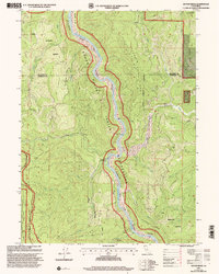
1997 Map of Ah Pah Ridge
USGS Topo · Published 2001About this map
The Klamath Wild and Scenic River snakes through a landscape defined by federal and state land management near the turn of the millennium. The Hoopa Valley Indian Reservation occupies much of the river corridor, where the water bends around Starwein Flat and past the McCovey Ranch. This topography is dominated by steep drainage basins, including the Blue Creek and Ah Pah Creek systems, which flow through heavily timbered sections of the Six Rivers National Forest.
Find a feature on this map
29 named features on this map. Tap any name to fly to it.
Don’t see what you’re looking for? This feature index may not catch every label — zoom into the map to look around manually.
Map Details
Editions of this 1997 Ah Pah Ridge Map
This is the sole edition of this map. No revisions or reprints were ever made.
Other maps of this area

1922 · Preston Peak
USGS Topo · 1:125,000

1925 · Hoopa
USGS Topo · 1:125,000

1929 · Crescent City
USGS Topo · 1:125,000

1945 · Ship Mountain
USGS Topo · 1:62,500

1945 · Orick
USGS Topo · 1:62,500

1945 · Requa
USGS Topo · 1:62,500

1945 · Tectah Creek
USGS Topo · 1:62,500

1948 · Weed
USGS Topo · 1:250,000

1949 · Eureka
USGS Topo · 1:250,000

1950 · Weed
USGS Topo · 1:250,000