
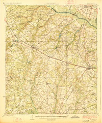
1920 Map of Aiken
USGS Topo · Published 1920About this map
The city of Aiken and its outlying rural districts are captured here during a period of transition in the early twentieth century, showing a landscape defined by an extensive network of community institutions. The map reveals a dense distribution of country schools and churches that served the agricultural population, including the Fountain Academy School, Foxtown School, and the Welcome Traveler Church. Transportation was anchored by the Southern Railway, which connects the settlements of Montmorenci and Oakwood to the regional hub, while established thoroughfares like Whiskey Road and Old Chavous Ferry Road suggest the enduring paths of local commerce.
Find a feature on this map
74 named features on this map. Tap any name to fly to it.
Don’t see what you’re looking for? This feature index may not catch every label — zoom into the map to look around manually.
Map Details
Editions of this 1920 Aiken Map
This is the sole edition of this map. No revisions or reprints were ever made.
Other maps of this area

1920 · Talatha
USGS Topo · 1:48,000

1921 · Augusta
USGS Topo · 1:62,500

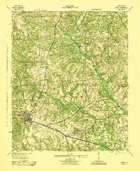
1921 · Aiken
USGS Topo · 1:62,500

1921 · Talatha
USGS Topo · 1:62,500

1923 · Williston
USGS Topo · 1:48,000

1923 · Warrenville
USGS Topo · 1:48,000
1927 · Williston
USGS Topo · 1:62,500

1928 · Warrenville
USGS Topo · 1:62,500
1943 · Aiken
USGS Topo · 1:62,500

1943 · Augusta East
USGS Topo · 1:125,000