
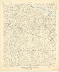
1927 Map of Williston
USGS Topo · Published 1927About this map
The Southern railroad corridor dictates the settlement pattern of this Barnwell and Aiken County landscape, connecting the towns of Williston, Elko, and Blackville. This 1920s topography reveals a rural economy deeply integrated with the water system, evidenced by the numerous small-scale operations like Bonnett Mill, Webb Mill, and Boylston Mill found along the creek branches. The South Fork Edisto River forms a prominent natural boundary in the northeast, giving way to swampy lowlands.
Find a feature on this map
46 named features on this map. Tap any name to fly to it.
Don’t see what you’re looking for? This feature index may not catch every label — zoom into the map to look around manually.
Map Details
Editions of this 1927 Williston Map
2 editions found
Other maps of this area

1919 · Olar
USGS Topo · 1:62,500

1919 · Bamberg
USGS Topo · 1:48,000

1919 · Allendale
USGS Topo · 1:62,500

1920 · Ellenton
USGS Topo · 1:48,000

1920 · Bamberg
USGS Topo · 1:62,500

1920 · Aiken
USGS Topo · 1:48,000

1920 · Talatha
USGS Topo · 1:48,000

1921 · Aiken
USGS Topo · 1:62,500

1921 · Talatha
USGS Topo · 1:62,500

1921 · Ellenton
USGS Topo · 1:62,500