
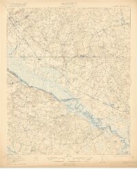
1921 Map of Ellenton
USGS Topo · Published 1921About this map
The Savannah River defines the border between South Carolina and Georgia in this early 20th-century landscape, a region characterized by dispersed agrarian settlements and a thriving river-and-rail economy. The Charleston and Western Carolina railroad provides the primary land corridor, connecting river towns like Ellenton and Dunbarton. This geography is particularly noteworthy for capturing the community structure of the Barnwell and Aiken county areas decades before large-scale land acquisitions fundamentally altered the local map.
Find a feature on this map
63 named features on this map. Tap any name to fly to it.
Don’t see what you’re looking for? This feature index may not catch every label — zoom into the map to look around manually.
Map Details
Editions of this 1921 Ellenton Map
2 editions found
Other maps of this area

1919 · Allendale
USGS Topo · 1:62,500

1920 · Ellenton
USGS Topo · 1:48,000

1920 · Hilltonia
USGS Topo · 1:62,500

1920 · Millen
USGS Topo · 1:62,500

1920 · Greens Cut
USGS Topo · 1:62,500

1920 · Peeples
USGS Topo · 1:62,500

1920 · Talatha
USGS Topo · 1:48,000

1921 · Augusta
USGS Topo · 1:62,500

1921 · Talatha
USGS Topo · 1:62,500

1923 · Williston
USGS Topo · 1:48,000