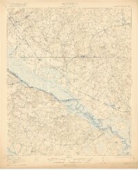
1921 Map of Ellenton
USGS Topo · Published 1921About this map
Ellenton and Dumbarton anchor this agricultural landscape along the South Carolina side of the river, just years before federal projects would fundamentally alter the region's geography. The Savannah River serves as the primary boundary and artery, dotted with historic river access points such as Steel Creek Landing and the evocatively named Little Hell Landing. Transportation and commerce are defined by the Atlantic Coast Line and the Charleston and Western Carolina railroads, which facilitated the growth of rural hubs like Meyers Mill and Robbins.
Find a feature on this map
60 named features on this map. Tap any name to fly to it.
Don’t see what you’re looking for? This feature index may not catch every label — zoom into the map to look around manually.
Map Details
Editions of this 1921 Ellenton Map
2 editions found
Other maps of this area

1919 · Allendale
USGS Topo · 1:62,500

1920 · Ellenton
USGS Topo · 1:48,000

1920 · Hilltonia
USGS Topo · 1:62,500

1920 · Millen
USGS Topo · 1:62,500

1920 · Greens Cut
USGS Topo · 1:62,500

1920 · Peeples
USGS Topo · 1:62,500

1920 · Talatha
USGS Topo · 1:48,000

1921 · Augusta
USGS Topo · 1:62,500

1921 · Talatha
USGS Topo · 1:62,500

1921 · Ellenton
USGS Topo · 1:62,500