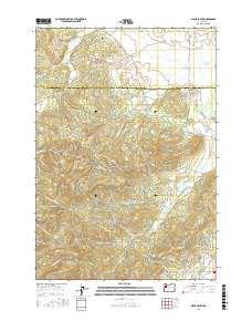
2017 Map of Airlie South
USGS Topo · Published 2017About this map
Williams Cem and the settlement of Airlie define the northern reaches of this landscape where the Polk Co and Benton Co line divides the valley. The terrain is marked by significant elevations including Forest Peak, Pride Peak, and Vineyard Mtn, creating a drainage network that feeds Soap Cr and Maxfield Cr. Water management is prominent throughout the area, evidenced by the Kenney Reservoir, Oakshire Reservoir, and Johnson Reservoir. The road network, including the aptly named Sauerkraut Rd and Beef Barn Rd, reflects the agricultural and rural character of these hills. Near the southern edge, the Lewisburg Saddle and Sulphur Springs suggest natural landmarks long known to local residents, while the eastern slopes above Writsman Brook show more recent residential development patterns along streets like NW Cardinal Dr.
Find a feature on this map
81 named features on this map. Tap any name to fly to it.
Don’t see what you’re looking for? This feature index may not catch every label — zoom into the map to look around manually.
Map Details
Editions of this 2017 Airlie South Map
This is the sole edition of this map. No revisions or reprints were ever made.
Other maps of this area

1913 · Philomath
USGS Topo · 1:31,680

1913 · Oakville
USGS Topo · 1:31,680

1913 · Wells
USGS Topo · 1:31,680

1914 · Independence
USGS Topo · 1:31,680

1914 · Soap Creek
USGS Topo · 1:31,680

1916 · Albany
USGS Topo · 1:62,500

1917 · Salem
USGS Topo · 1:62,500

1921 · Corvallis
USGS Topo · 1:62,500

1922 · Airlie
USGS Topo · 1:31,680

1940 · Salem
USGS Topo · 1:62,500