
1913 Map of Wells
USGS Topo · Published 1913About this map
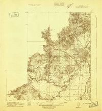
The Southern Pacific (West Side Division) line anchors this 1913 survey of the Willamette Valley, linking rural hubs from Suver down to Wells PO Wellsdate Sta. The landscape is defined by the complex hydrology of the Willamette River and its associated channels, including Crooked Slough, Powers Slough, and the Little Willamette River. In the southwest, the State Game Farm and Mountain Sch mark the area near Lewisburg, while the central terrain is punctuated by Coffin Butte and a network of local thoroughfares like Ryals Lane. This period map captures the agricultural and educational infrastructure of Benton and Polk counties through several neighborhood schools, such as Spring Sch and Oakgrove Sch, and the presence of the Corvallis and Eastern railroad corridor.
Find a feature on this map
32 named features on this map. Tap any name to fly to it.
Don’t see what you’re looking for? This feature index may not catch every label — zoom into the map to look around manually.
Map Details
Editions of this 1913 Wells Map
This is the sole edition of this map. No revisions or reprints were ever made.
Other maps of this area

1911 · Tangent
USGS Topo · 1:31,680

1912 · Jefferson
USGS Topo · 1:31,680
1913 · Philomath
USGS Topo · 1:31,680

1913 · Oakville
USGS Topo · 1:31,680

1914 · Independence
USGS Topo · 1:31,680

1914 · Soap Creek
USGS Topo · 1:31,680

1915 · Sidney
USGS Topo · 1:31,680

1916 · Albany
USGS Topo · 1:62,500

1917 · Salem
USGS Topo · 1:62,500

1921 · Corvallis
USGS Topo · 1:62,500