
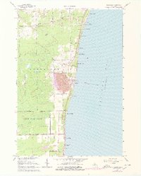
1966 Map of Alabaster
USGS Topo · Published 1968About this map
Industrial gypsum operations define the landscape near the shoreline of Saginaw Bay, where a massive quarry and complex of conveyors dominate the settlement of Alabaster. This mid-1960s survey captures the intersection of heavy industry and Lake Huron recreation, with a string of coastal residential developments like Anderson Bayview and Cedar Haven lining the water. The Detroit and Mackinac railroad serves as the primary artery for the region's output, branching toward the interior at Alabaster Junction.
Find a feature on this map
59 named features on this map. Tap any name to fly to it.
Don’t see what you’re looking for? This feature index may not catch every label — zoom into the map to look around manually.
Map Details
Editions of this 1966 Alabaster Map
2 editions found
Other maps of this area

1954 · Tawas City
USGS Topo · 1:250,000

1958 · Tawas City
USGS Topo · 1:250,000

1959 · Tawas City
USGS Topo · 1:62,500

1959 · East Tawas
USGS Topo · 1:62,500

1966 · Point Lookout
USGS Topo · 1:24,000

1966 · Au Gres
USGS Topo · 1:24,000

1966 · National City
USGS Topo · 1:24,000
1970 · Charity Island
USGS Topo · 1:24,000

1984 · Tawas City
USGS Topo · 1:100,000
1989 · East Tawas
USGS Topo · 1:24,000