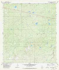
1980 Map of Alamito Creek NE
USGS Topo · Published 1980About this map
Becerra Creek and its many winding tributaries define the topography of this Webb County landscape as it appeared in 1980. This area of South Texas shows clear evidence of late-twentieth-century industrial activity, with several Oil Well sites, a Drill Hole, and numerous storage Tanks scattered across the undulating terrain. A remote Landing Strip and various pipelines suggest the infrastructure required to service these dispersed petroleum operations. The map also features the crossing of Salado Creek and several isolated water tanks or small reservoirs like Pintas, which are critical features in this arid brushland environment. These small-scale modifications to the land reflect a period of intensive resource extraction and ranching utility typical of the region's rural development during the era.
Find a feature on this map
8 named features on this map. Tap any name to fly to it.
Don’t see what you’re looking for? This feature index may not catch every label — zoom into the map to look around manually.
Map Details
Editions of this 1980 Alamito Creek NE Map
This is the sole edition of this map. No revisions or reprints were ever made.
Other maps of this area

1929 · Cotulla
USGS Topo · 1:125,000

1953 · Crystal City
USGS Topo · 1:250,000

1955 · Crystal City
USGS Topo · 1:250,000

1956 · Becerra
USGS Topo · 1:62,500

1956 · Piedra Creek
USGS Topo · 1:62,500

1956 · Las Mujeres
USGS Topo · 1:62,500

1956 · Laredo
USGS Topo · 1:250,000

1957 · Caiman Creek
USGS Topo · 1:62,500

1961 · Crystal City
USGS Topo · 1:250,000

1968 · Crystal City
USGS Topo · 1:250,000