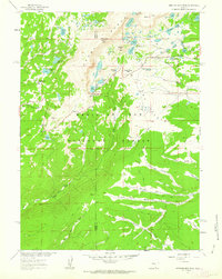
1961 Map of Albany
USGS Topo · Published 1984About this map
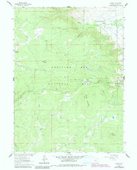
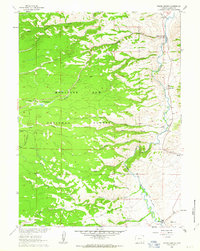
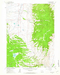
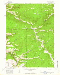
The settlement of Albany sits along the Union Pacific tracks at the eastern edge of the Medicine Bow National Forest, serving as a gateway to the high timber and mineral lands of the Laramie Range. This 1961 survey, updated in the early 1980s, reveals a landscape defined by water management and resource extraction, notably featuring the Rob Roy Reservoir and a significant Aqueduct system cutting through the southern forest. High-altitude parks like Cinnabar Park and Muddy Park break the timberline, while Spruce Mountain is capped by the VABM 10003 Lookout. Historical mining activity is evident in Moores Gulch and near Douglas Creek, where scattered Mine and Prospects labels indicate the region's enduring draw for prospectors. The map also documents the transition from the flat Centennial Valley near Deerwood into the steep drainages of the Middle Fork Little Laramie River.
Find a feature on this map
33 named features on this map. Tap any name to fly to it.
Don’t see what you’re looking for? This feature index may not catch every label — zoom into the map to look around manually.
Map Details
Editions of this 1961 Albany Map
This is the sole edition of this map. No revisions or reprints were ever made.
Other maps of this area

1906 · Medicine Bow
USGS Topo · 1:125,000

1908 · Medicine Bow
USGS Topo · 1:125,000

1954 · Rawlins
USGS Topo · 1:250,000

1958 · Rawlins
USGS Topo · 1:250,000
1961 · Woods Landing
USGS Topo · 1:24,000
1961 · Lake Owen
USGS Topo · 1:24,000
1961 · Horatio Rock
USGS Topo · 1:24,000
1961 · Medicine Bow Peak
USGS Topo · 1:24,000
1961 · Foxpark
USGS Topo · 1:24,000
1961 · Centennial
USGS Topo · 1:24,000