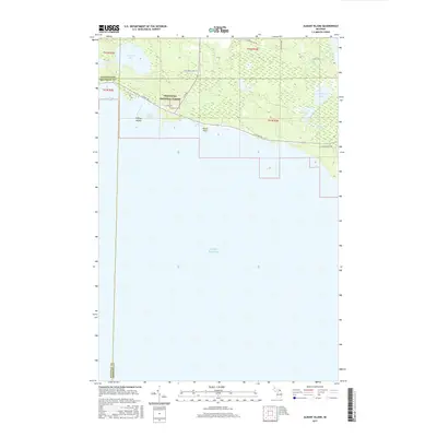
2017 Map of Albany Island
USGS Topo · Published 2017About this map
The Hiawatha National Forest dominates the northern reaches of this coastal Michigan landscape, where the Upper Peninsula meets the cold waters of Lake Huron. The terrain is defined by a dense network of inland waters and marshy drainage, including Big Trout Lake and Little Trout Lake, which feed into Trout Cr. Along the shoreline, Albany Harbor and Albany Bay provide sheltered waters behind the protective landmass of Albany Island. The map illustrates a primarily undeveloped wilderness, with a sparse grid of roads such as S Scenic Rd and S Campground Rd tracing the lake's edge. This 2017 data captures the intersection of Chippewa and Mackinac counties, highlighting the remote character of the Les Cheneaux region before more significant coastal development. Smaller features like Cranberry Lake and Joe Straw Cr indicate the intricate hydrology of this timbered and wetland-rich environment.
Find a feature on this map
26 named features on this map. Tap any name to fly to it.
Don’t see what you’re looking for? This feature index may not catch every label — zoom into the map to look around manually.
Map Details
Editions of this 2017 Albany Island Map
This is the sole edition of this map. No revisions or reprints were ever made.
Other maps of this area

1954 · Alpena
USGS Topo · 1:250,000

1954 · Sault Sainte Marie
USGS Topo · 1:250,000

1955 · Cheboygan
USGS Topo · 1:250,000

1956 · Sault Sainte Marie
USGS Topo · 1:250,000

1957 · Alpena
USGS Topo · 1:250,000

1957 · Sault Sainte Marie
USGS Topo · 1:250,000

1958 · Cheboygan
USGS Topo · 1:250,000

1958 · Alpena
USGS Topo · 1:250,000

1958 · Sault Sainte Marie
USGS Topo · 1:250,000

1961 · Blind River
USGS Topo · 1:250,000