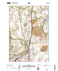
2020 Map of Albany
USGS Topo · Published 2020About this map
The Willamette River and Santiam River converge in this Willamette Valley landscape, where the city of Albany sits at the junction of major rail and river corridors. This 2020 map documents the regional infrastructure of Linn, Marion, and Benton Counties, including the Linn County Courthouse and a dense network of local airfields like Albany Municipal Airport and Lambert Field. The map reveals a high concentration of memorial sites for genealogists, from the Masonic Cem in the city center to rural plots like the Simison Hale Cem near The Cliff.
Find a feature on this map
171 named features on this map. Tap any name to fly to it.
Don’t see what you’re looking for? This feature index may not catch every label — zoom into the map to look around manually.
Map Details
Editions of this 2020 Albany Map
This is the sole edition of this map. No revisions or reprints were ever made.
Other maps of this area

1911 · Lebanon
USGS Topo · 1:31,680

1911 · Tangent
USGS Topo · 1:31,680

1912 · Jefferson
USGS Topo · 1:31,680

1913 · Oakville
USGS Topo · 1:31,680

1913 · Wells
USGS Topo · 1:31,680

1914 · Independence
USGS Topo · 1:31,680

1915 · Sidney
USGS Topo · 1:31,680

1916 · Albany
USGS Topo · 1:62,500

1917 · Salem
USGS Topo · 1:62,500

1921 · Lebanon
USGS Topo · 1:62,500