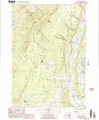
1986 Map of Albany
USGS Topo · Published 1987About this map
Craftsbury and Craftsbury Common anchor the southern portion of this landscape, where the Black River winds through the valley floor toward Albany. The terrain is dominated by the steep rises of the Lowell Mountains, which separate the drainage of Lake Eden from the Wild Branch watershed. Significant conservation lands are represented by the Wild Branch State Wildlife Management Area, stretching across the central ridges between the towns. Local industry and water management are evident at Mill Village, where a Conc Dam sits at the outlet of Little Hosmer Pond. The network of 4wd tracks and forest roads provides a detailed look at the rural infrastructure in the Orleans and Lamoille county borderlands during the mid-1980s.
Find a feature on this map
31 named features on this map. Tap any name to fly to it.
Don’t see what you’re looking for? This feature index may not catch every label — zoom into the map to look around manually.
Map Details
Editions of this 1986 Albany Map
2 editions found
Other maps of this area

1919 · Montgomery
USGS Topo · 1:62,500

1920 · Montgomery
USGS Topo · 1:62,500

1920 · Irasburg
USGS Topo · 1:62,500

1923 · Irasburg
USGS Topo · 1:48,000

1925 · Irasburg
USGS Topo · 1:62,500

1925 · Jay Peak
USGS Topo · 1:62,500

1927 · Hyde Park
USGS Topo · 1:48,000

1928 · Hardwick
USGS Topo · 1:62,500

1930 · Hyde Park
USGS Topo · 1:62,500

1934 · Hardwick
USGS Topo · 1:48,000