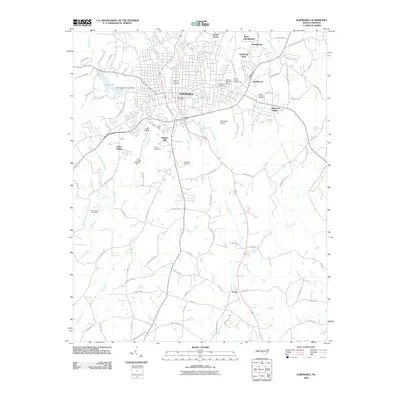
2010 Map of Albemarle
USGS Topo · Published 2010About this map
Albemarle serves as the central hub of this 2010 landscape, where the municipal footprint expands into residential developments like Windsor Hills, Heathwood, and Eastwood Park. The city's infrastructure is anchored by the Albemarle Post Office and the Albemarle Airport, while the Stanly County Fairgrounds and Fairview Memorial Park provide dedicated public spaces for the community. The topography is defined by a dense network of watercourses, including Little Long Creek and Poplin Creek, which drain toward the larger Long Creek system.
Find a feature on this map
92 named features on this map. Tap any name to fly to it.
Don’t see what you’re looking for? This feature index may not catch every label — zoom into the map to look around manually.
Map Details
Editions of this 2010 Albemarle Map
This is the sole edition of this map. No revisions or reprints were ever made.
Other maps of this area

1953 · Charlotte
USGS Topo · 1:250,000

1954 · Charlotte
USGS Topo · 1:250,000

1956 · Mount Gilead West
USGS Topo · 1:24,000

1957 · Mount Pleasant
USGS Topo · 1:62,500

1957 · Albemarle
USGS Topo · 1:62,500

1960 · Charlotte
USGS Topo · 1:250,000

1962 · Charlotte
USGS Topo · 1:250,000
1971 · Oakboro
USGS Topo · 1:24,000
1971 · Aquadale
USGS Topo · 1:24,000
1977 · Albemarle SE
USGS Topo · 1:24,000