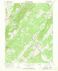
1967 Map of Alberene
USGS Topo · Published 1968About this map
Green Mountain and Dudley Mountain dominate this central Virginia landscape, which was meticulously documented in the late 1960s by the Commonwealth of Virginia and the USGS. The settlement of Alberene serves as a focal point for local history, surrounded by numerous small family and community cemeteries. Evidence of the region's industrial and agricultural past is visible through several labeled quarries and a network of jeep trails and unimproved roads.
Find a feature on this map
50 named features on this map. Tap any name to fly to it.
Don’t see what you’re looking for? This feature index may not catch every label — zoom into the map to look around manually.
Map Details
Editions of this 1967 Alberene Map
2 editions found
Other maps of this area

1891 · Palmyra
USGS Topo · 1:125,000

1892 · Buckingham
USGS Topo · 1:125,000

1892 · Gordonsville
USGS Topo · 1:125,000

1892 · Harrisonburg
USGS Topo · 1:125,000

1895 · Palmyra
USGS Topo · 1:125,000

1897 · Palmyra
USGS Topo · 1:125,000

1929 · Covesville
USGS Topo · 1:62,500

1931 · University
USGS Topo · 1:62,500

1935 · Charlottesville
USGS Topo · 1:62,500

1935 · Charlottesville And Vicinity
USGS Topo · 1:31,680