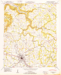
1950 Map of Albertville
USGS Topo · Published 1950About this map
Albertville sits atop the high Sand Mountain plateau, serving as a hub for the surrounding poultry and textile landscape of mid-century Marshall County. This 1950 survey highlights a time when the N C & St L railroad and the Florida Short Route anchored local commerce, connecting the town to rural outposts like Saratoga and McVille. To the north, the terrain drops sharply toward the Guntersville Reservoir, where Little Mountain State Park marks the transition from the plateau to the river valley.
Find a feature on this map
60 named features on this map. Tap any name to fly to it.
Don’t see what you’re looking for? This feature index may not catch every label — zoom into the map to look around manually.
Map Details
Editions of this 1950 Albertville Map
2 editions found
Other maps of this area

1885 · Gadsden
USGS Topo · 1:125,000

1888 · Gadsden
USGS Topo · 1:125,000

1892 · Gadsden
USGS Topo · 1:125,000

1895 · Gadsden
USGS Topo · 1:125,000

1903 · Gadsden
USGS Topo · 1:125,000

1936 · Painter
USGS Topo · 1:24,000

1936 · Guntersville
USGS Topo · 1:24,000

1936 · Mountainboro
USGS Topo · 1:24,000

1936 · Columbus City
USGS Topo · 1:24,000

1936 · Rodentown
USGS Topo · 1:24,000