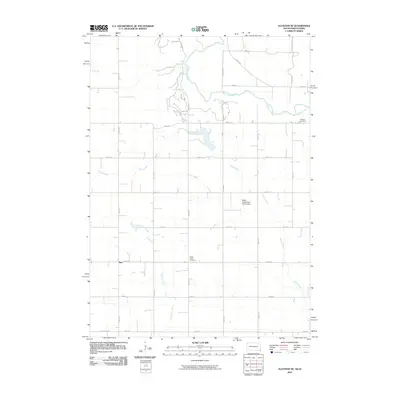
2010 Map of Alcester NE
USGS Topo · Published 2010About this map
Big Sioux River meanders across the border of Iowa and South Dakota, anchoring a rural landscape defined by agricultural section lines and small creek drainages. The 2010 topography shows a network of named waterways including Sargeant Creek and East Brule Creek feeding into the main river valley. Modern infrastructure like the Pattee Creek Flood Control Dam reflects mid-century efforts to manage the prairie watershed. Local heritage is preserved in the location of the settlement of Moe and rural burying grounds like Bethany Cemetery and North Trinity Cemetery. The map captures the transition from Iowa's Co Rd A54B to South Dakota's S Dakota Hwy 11, illustrating how state lines and local roads intersect in this high plains region.
Find a feature on this map
25 named features on this map. Tap any name to fly to it.
Don’t see what you’re looking for? This feature index may not catch every label — zoom into the map to look around manually.
Map Details
Editions of this 2010 Alcester NE Map
This is the sole edition of this map. No revisions or reprints were ever made.
Other maps of this area

1897 · Canton
USGS Topo · 1:125,000

1900 · Canton
USGS Topo · 1:125,000

1955 · Sioux Falls
USGS Topo · 1:250,000

1958 · Sioux Falls
USGS Topo · 1:250,000

1962 · Canton
USGS Topo · 1:24,000

1964 · Canton SW
USGS Topo · 1:24,000

1968 · Alcester NW
USGS Topo · 1:24,000

1968 · Alcester NE
USGS Topo · 1:24,000
1968 · Alcester
USGS Topo · 1:24,000
1968 · Alcester SE
USGS Topo · 1:24,000