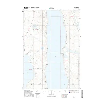
2017 Map of Alden
USGS Topo · Published 2017About this map
Torch Lake dominates this landscape of Northern Michigan, its deep blue expanse separating the shorelines of Milton and Helena Townships. On the western shore, the settlement of Kewadin sits near the head of Elk Lake, while the village of Alden anchors the southeastern corner where Spencer Creek meets the water. The map reveals a land defined by its glacial history, with several distinctive points extending into the water including Deepwater Point, French Point, and Indian Point.
Find a feature on this map
81 named features on this map. Tap any name to fly to it.
Don’t see what you’re looking for? This feature index may not catch every label — zoom into the map to look around manually.
Map Details
Editions of this 2017 Alden Map
This is the sole edition of this map. No revisions or reprints were ever made.
Other maps of this area

1954 · Central Lake
USGS Topo · 1:62,500

1954 · Traverse City
USGS Topo · 1:250,000

1955 · Cheboygan
USGS Topo · 1:250,000

1956 · Mancelona
USGS Topo · 1:62,500

1957 · Elk Rapids
USGS Topo · 1:62,500

1958 · Cheboygan
USGS Topo · 1:250,000

1958 · Traverse City
USGS Topo · 1:250,000

1961 · Boyne City
USGS Topo · 1:62,500

1975 · Mancelona NW
USGS Topo · 1:24,000
1983 · Central Lake
USGS Topo · 1:25,000