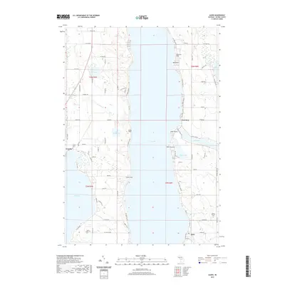
2019 Map of Alden
USGS Topo · Published 2019About this map
Torch Lake dominates this Antrim County landscape, serving as a massive blue corridor between the settlements of Kewadin on its western shore and Alden to the southeast. The geography is defined by a series of dramatic points extending into the water, including Lone Tree Point, Stony Point, and French Point. These features suggest a shoreline shaped by glacial activity, creating protected coves and prominent lookout positions along the lake's edge.
Find a feature on this map
49 named features on this map. Tap any name to fly to it.
Don’t see what you’re looking for? This feature index may not catch every label — zoom into the map to look around manually.
Map Details
Editions of this 2019 Alden Map
This is the sole edition of this map. No revisions or reprints were ever made.
Other maps of this area

1954 · Central Lake
USGS Topo · 1:62,500

1954 · Traverse City
USGS Topo · 1:250,000

1955 · Cheboygan
USGS Topo · 1:250,000

1956 · Mancelona
USGS Topo · 1:62,500

1957 · Elk Rapids
USGS Topo · 1:62,500

1958 · Cheboygan
USGS Topo · 1:250,000

1958 · Traverse City
USGS Topo · 1:250,000

1961 · Boyne City
USGS Topo · 1:62,500

1975 · Mancelona NW
USGS Topo · 1:24,000
1983 · Central Lake
USGS Topo · 1:25,000