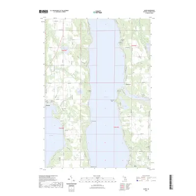
2023 Map of Alden
USGS Topo · Published 2023About this map
Torch Lake dominates this Antrim County landscape, serving as the central axis for the surrounding settlements and terrain. Along its eastern shore, the village of Alden sits near the mouth of the Clam River, while Kewadin occupies the western heights near Elk Lake. The map reveals a land defined by its transition from water to timbered ridges, featuring significant genealogical sites such as the Kewadin Indian Mission Cem and Sacred Heart Cem. The Chain Of Lakes Water Trl winds through these interconnected basins, including Thayer Lake and Lake Maplehurst, illustrating the historical importance of these waterways for transport and recreation. Distinctive shoreline features like French Point, Lone Tree Point, and Deepwater Point provide specific geographic anchors for local history researchers and land surveyors alike.
Find a feature on this map
86 named features on this map. Tap any name to fly to it.
Don’t see what you’re looking for? This feature index may not catch every label — zoom into the map to look around manually.
Map Details
Editions of this 2023 Alden Map
This is the sole edition of this map. No revisions or reprints were ever made.
Other maps of this area

1954 · Central Lake
USGS Topo · 1:62,500

1954 · Traverse City
USGS Topo · 1:250,000

1955 · Cheboygan
USGS Topo · 1:250,000

1956 · Mancelona
USGS Topo · 1:62,500

1957 · Elk Rapids
USGS Topo · 1:62,500

1958 · Cheboygan
USGS Topo · 1:250,000

1958 · Traverse City
USGS Topo · 1:250,000

1961 · Boyne City
USGS Topo · 1:62,500

1975 · Mancelona NW
USGS Topo · 1:24,000
1983 · Central Lake
USGS Topo · 1:25,000