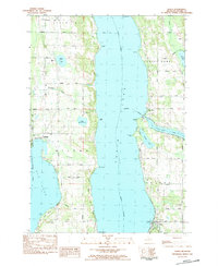
1983 Map of Alden
USGS Topo · Published 1984About this map
Torch Lake dominates this Antrim County landscape, its deep blue expanse separating the townships of Milton, Forest Home, and Helena in the early 1980s. The settlement of Alden anchors the southeastern shore near Valleau Landing, while Kewadin sits to the west between the massive lake and Elk Lake. This era shows a transition from traditional agricultural lands toward seasonal recreation, evidenced by Camp Maplehurst and numerous public access points along West Torch Lake Drive. Genealogists will find several burial grounds, including South Milton Cem, Township Cem, and Sacred Heart Cem near the western shore. The geography is defined by prominent points such as Deepwater Point and French Point, while the narrow Clam River connects Clam Lake to the eastern shore of the main basin.
Find a feature on this map
65 named features on this map. Tap any name to fly to it.
Don’t see what you’re looking for? This feature index may not catch every label — zoom into the map to look around manually.
Map Details
Editions of this 1983 Alden Map
This is the sole edition of this map. No revisions or reprints were ever made.
Other maps of this area

1954 · Central Lake
USGS Topo · 1:62,500

1954 · Traverse City
USGS Topo · 1:250,000

1955 · Cheboygan
USGS Topo · 1:250,000

1956 · Mancelona
USGS Topo · 1:62,500

1957 · Elk Rapids
USGS Topo · 1:62,500

1958 · Cheboygan
USGS Topo · 1:250,000

1958 · Traverse City
USGS Topo · 1:250,000

1961 · Boyne City
USGS Topo · 1:62,500

1975 · Mancelona NW
USGS Topo · 1:24,000
1983 · Central Lake
USGS Topo · 1:25,000