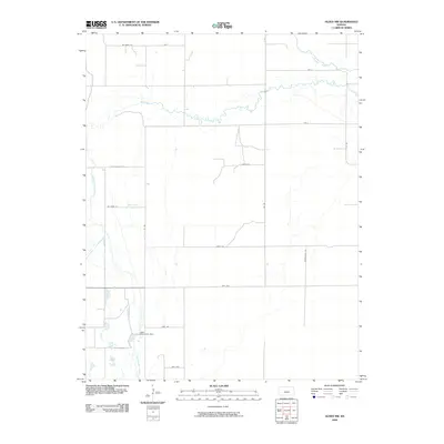
2009 Map of Alden NW
USGS Topo · Published 2009About this map
Arkansas River waters and the meandering course of Salt Creek define this agricultural landscape in Reno County during the early 21st century. The terrain is characterized by a precise grid of county roads, such as Netherland Rd and 1st Rd, which partition the fertile plains into distinct sections. This drainage pattern highlights the importance of water management in the region, evidenced by features like the Lake Darrynane Dam and the descriptively named Dead Horse Slough. To the southwest, Rattlesnake Creek winds through the terrain, further illustrating the complex hydrology that supports the local farming economy. The presence of these named waterways amidst a highly structured road network provides a clear view of the rural development and land-use priorities in this part of Kansas.
Find a feature on this map
19 named features on this map. Tap any name to fly to it.
Don’t see what you’re looking for? This feature index may not catch every label — zoom into the map to look around manually.
Map Details
Editions of this 2009 Alden NW Map
This is the sole edition of this map. No revisions or reprints were ever made.
Other maps of this area

1891 · Great Bend
USGS Topo · 1:125,000

1893 · Great Bend
USGS Topo · 1:125,000

1894 · Lyons
USGS Topo · 1:125,000

1955 · Great Bend
USGS Topo · 1:250,000

1957 · Great Bend
USGS Topo · 1:250,000

1957 · Ellinwood
USGS Topo · 1:24,000

1958 · Great Bend
USGS Topo · 1:250,000

1967 · Alden
USGS Topo · 1:24,000

1967 · Alden NW
USGS Topo · 1:24,000
1970 · Raymond
USGS Topo · 1:24,000