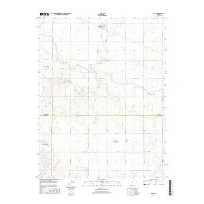
2015 Map of Alden
USGS Topo · Published 2015About this map
The town of Alden sits in the northern section of this survey, organized around a traditional grid that includes Pioneer St and 4th St. The surrounding landscape is defined by the significant meanders of the Arkansas River, which flows through the center of the sheet, joined by smaller tributaries like Salt Creek and Peace Cr. The terrain reflects the agricultural character of central Kansas, partitioned by an extensive section-line road network such as Jordan Springs Rd and Huntsville Rd. Genealogists and local historians will find value in the placement of the Peace Valley Cem, located south of the river. The map also delineates the political boundary of Rice Co Reno Co, marking where the southern agricultural fields transition across the county line.
Find a feature on this map
39 named features on this map. Tap any name to fly to it.
Don’t see what you’re looking for? This feature index may not catch every label — zoom into the map to look around manually.
Map Details
Editions of this 2015 Alden Map
This is the sole edition of this map. No revisions or reprints were ever made.
Other maps of this area

1894 · Lyons
USGS Topo · 1:125,000

1955 · Great Bend
USGS Topo · 1:250,000

1957 · Great Bend
USGS Topo · 1:250,000

1958 · Great Bend
USGS Topo · 1:250,000

1966 · Sterling SW
USGS Topo · 1:24,000

1967 · Alden
USGS Topo · 1:24,000

1967 · Alden NW
USGS Topo · 1:24,000
1967 · Sterling
USGS Topo · 1:24,000

1970 · Lyons
USGS Topo · 1:24,000
1970 · Raymond
USGS Topo · 1:24,000