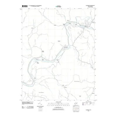
2011 Map of Alderson
USGS Topo · Published 2011About this map
The Greenbrier River dictates the landscape of this West Virginia corridor, winding past the regional center of Alderson and the long-established resort community at Pence Springs. This 2011 survey captures the area's transport and utility infrastructure, from the Pence Springs Post Office to the Hinton-Alderson Airport, tucked into a bend of the river. The terrain is defined by prominent ridges like Wolf Creek Mountain and Wind Creek Mountain, which hem in a network of smaller hollows and creek-side settlements. Local history is etched into the landscape through place names like Lowell, Glenray, and Clayton, connected by a web of mountain roads such as the Red Sulfur Tpke and Valley Heights Rd. Smaller landmarks like Johnson Island and the rural community of Creamery illustrate the persistent settlement patterns in this part of Monroe and Summers counties.
Find a feature on this map
62 named features on this map. Tap any name to fly to it.
Don’t see what you’re looking for? This feature index may not catch every label — zoom into the map to look around manually.
Map Details
Editions of this 2011 Alderson Map
This is the sole edition of this map. No revisions or reprints were ever made.
Other maps of this area

1887 · Hinton
USGS Topo · 1:125,000

1892 · Hinton
USGS Topo · 1:125,000

1912 · Meadow Creek
USGS Topo · 1:48,000

1912 · Big Bend
USGS Topo · 1:62,500

1914 · Big Bend
USGS Topo · 1:62,500

1915 · Meadow Creek
USGS Topo · 1:62,500

1921 · Alderson
USGS Topo · 1:48,000

1921 · Clintonville
USGS Topo · 1:48,000

1923 · Clintonville
USGS Topo · 1:62,500
1923 · Alderson
USGS Topo · 1:62,500