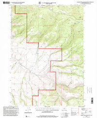
1998 Map of Aldrich Mountain South
USGS Topo · Published 2000About this map
Aldrich Mountain dominates this portion of the Malheur National Forest, where steep drainages and isolated springs define the high-elevation landscape. The topography is shaped by the complex network of Murderers Creek, including its East Fork and South Fork, which carve deep canyons through the Aldrich Mountains. This area, managed under the Bear Valley Ranger District, shows a geography of named gulches and ridges that speak to the region's rugged character, from Chickenhouse Gulch to the distinctive Shake Table plateau in the southeast corner.
Find a feature on this map
41 named features on this map. Tap any name to fly to it.
Don’t see what you’re looking for? This feature index may not catch every label — zoom into the map to look around manually.
Map Details
Editions of this 1998 Aldrich Mountain South Map
This is the sole edition of this map. No revisions or reprints were ever made.
Other maps of this area

1932 · Dayville
USGS Topo · 1:125,000

1936 · Dayville
USGS Topo · 1:125,000

1940 · Aldrich Mtn.
USGS Topo · 1:62,500

1943 · Aldrich Mtn.
USGS Topo · 1:62,500

1955 · Canyon City
USGS Topo · 1:250,000

1959 · Canyon City
USGS Topo · 1:250,000

1961 · Izee
USGS Topo · 1:62,500

1972 · Big Weasel Sprs
USGS Topo · 1:24,000
1972 · Aldrich Mountain North
USGS Topo · 1:24,000
1972 · Aldrich Gulch
USGS Topo · 1:24,000