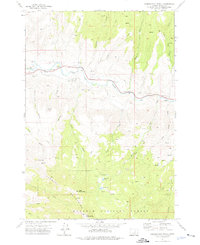
1972 Map of Aldrich Mountain North
USGS Topo · Published 1976About this map
The John Day River carves through this portion of Grant County, serving as the central artery for a landscape defined by sharp drainage gulches and high summits. This 1970s record highlights the rugged accessibility of the area through numerous jeep trails that navigate the slopes of the Aldrich Mountains. Local history is anchored by specific family and geographical markers, such as Stewarts Crossing and the Aldrich Grave, which hint at early settlement and land use near the riverbanks. High-altitude hydrology is represented by a cluster of mountain waters including Pinchot Lake, Roosevelt Lake, and Stewart Lake, all located within the northern reaches of the Malheur National Forest. The map also identifies the Lookout on Aldrich Mtn, a critical vantage point for forest management in this timber-rich terrain.
Find a feature on this map
36 named features on this map. Tap any name to fly to it.
Don’t see what you’re looking for? This feature index may not catch every label — zoom into the map to look around manually.
Map Details
Editions of this 1972 Aldrich Mountain North Map
2 editions found
Other maps of this area

1932 · Dayville
USGS Topo · 1:125,000

1936 · Dayville
USGS Topo · 1:125,000

1940 · Aldrich Mtn.
USGS Topo · 1:62,500

1943 · Aldrich Mtn.
USGS Topo · 1:62,500

1951 · Courtrock
USGS Topo · 1:62,500

1953 · Picture
USGS Topo · 1:62,500

1955 · Canyon City
USGS Topo · 1:250,000

1959 · Canyon City
USGS Topo · 1:250,000

1972 · Big Weasel Sprs
USGS Topo · 1:24,000
1972 · Aldrich Gulch
USGS Topo · 1:24,000