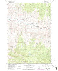
1972 Map of Aldrich Mountain North
USGS Topo · Published 1984About this map
The John Day River carves through this northern section of the Aldrich Mountains within the Malheur National Forest. This 1970s landscape is defined by its water sources and rugged topography, featuring a network of drainages such as Stockdale Creek and Marks Creek that feed into the main river valley. Notable human marks on this terrain include the Aldrich Grave and the small settlement at Stewarts Crossing, alongside infrastructure like an Aqueduct and a Radio Tower. Higher elevations reveal several small alpine bodies of water, including Stewart Lake, Roosevelt Lake, and Pincher Lake. The map details a transition from the river basin up toward the peaks of Aldrich Mtn and Little Aldrich Mtn, providing a record of 20th-century land management and remote Oregon geography.
Find a feature on this map
35 named features on this map. Tap any name to fly to it.
Don’t see what you’re looking for? This feature index may not catch every label — zoom into the map to look around manually.
Map Details
Editions of this 1972 Aldrich Mountain North Map
2 editions found
Other maps of this area

1932 · Dayville
USGS Topo · 1:125,000

1936 · Dayville
USGS Topo · 1:125,000

1940 · Aldrich Mtn.
USGS Topo · 1:62,500

1943 · Aldrich Mtn.
USGS Topo · 1:62,500

1951 · Courtrock
USGS Topo · 1:62,500

1953 · Picture
USGS Topo · 1:62,500

1955 · Canyon City
USGS Topo · 1:250,000

1959 · Canyon City
USGS Topo · 1:250,000

1972 · Big Weasel Sprs
USGS Topo · 1:24,000
1972 · Aldrich Mountain North
USGS Topo · 1:24,000