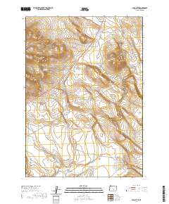
2020 Map of Alec Butte
USGS Topo · Published 2020About this map
Alec Butte rises as a prominent landmark in this high-desert portion of Harney County, characterized by a complex network of seasonal drainages and water management features. The landscape is defined by the flow of Wilson Cr and Big Stick Cr, which carve through the terrain alongside man-made infrastructure like the Shroder Reservoir and Big Tank. These features suggest a history of ranching and water conservation essential for life in this arid region of southeastern Oregon. Sparse transportation routes, including Big Stick Rd and N Dry Valley Rd, provide the only access through the vast township and range sections that organize this territory. The orientation of these roads and the placement of the Little Tank Cr drainage highlight the intersection of natural topography and human efforts to navigate and utilize the open range.
Find a feature on this map
16 named features on this map. Tap any name to fly to it.
Don’t see what you’re looking for? This feature index may not catch every label — zoom into the map to look around manually.
Map Details
Editions of this 2020 Alec Butte Map
This is the sole edition of this map. No revisions or reprints were ever made.
Other maps of this area

1955 · Burns
USGS Topo · 1:250,000

1958 · Burns
USGS Topo · 1:250,000

1959 · Burns
USGS Topo · 1:250,000

1980 · Capehart Lake
USGS Topo · 1:24,000

1980 · Squaw Butte
USGS Topo · 1:24,000

1980 · Alec Butte
USGS Topo · 1:24,000

1980 · Hay Lake
USGS Topo · 1:24,000

1980 · Wagontire Mtn East
USGS Topo · 1:24,000

1980 · Lake on The Trail
USGS Topo · 1:24,000
1984 · Goose Egg Butte
USGS Topo · 1:24,000