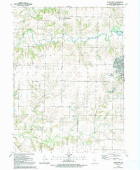
1992 Map of Aledo West
USGS Topo · Published 1992About this map
Mercer County’s agricultural heartland is documented here during the early 1990s, anchored by the seat of Aledo and the surrounding rural townships of Millersburg, Abington, and Ohio Grove. The landscape is defined by the winding course of the Edwards River and Pope Creek, which cut through a grid of section lines and gravel roads. Evidence of former transportation networks is visible in the Old Railroad Grade running east-west toward the village of Joy. For family historians, the map identifies several local landmarks and places of worship, including Peniel Ch, Popes River Ch, and the Hospital County Nursing Home. Numerous burial grounds such as Oak Ridge Cem, Griffith Cem, and Candor Cem are clearly marked across the prairie, providing precise locations for genealogical research in this part of Western Illinois.
Find a feature on this map
32 named features on this map. Tap any name to fly to it.
Don’t see what you’re looking for? This feature index may not catch every label — zoom into the map to look around manually.
Map Details
Editions of this 1992 Aledo West Map
This is the sole edition of this map. No revisions or reprints were ever made.
Other maps of this area

1912 · Milan
USGS Topo · 1:62,500

1916 · Edgington
USGS Topo · 1:62,500

1923 · Alexis
USGS Topo · 1:62,500

1925 · Alexis
USGS Topo · 1:62,500

1935 · Keithsburg
USGS Topo · 1:48,000

1938 · Edgington
USGS Topo · 1:62,500

1941 · Keithsburg
USGS Topo · 1:62,500

1944 · Milan
USGS Topo · 1:62,500

1953 · Buffalo Prairie
USGS Topo · 1:24,000
1953 · Aledo East
USGS Topo · 1:24,000