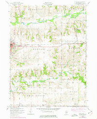
1953 Map of Aledo East
USGS Topo · Published 1977About this map
Aledo serves as the focal point for this mid-century look at Mercer County, where the Chicago Burlington and Quincy Railroad passes through the center of town. The landscape is defined by the winding paths of the Edwards River to the north and Pope Creek to the south, with rural life organized around townships like Perryton, Greene, and Ohio Grove. Industrial activity is evident at Shale City, where a Kiln is marked, while the small settlements of Warlock and Old Gilchrist appear along the rail lines and regional roads. Genealogists will find a high density of family-oriented landmarks, including the Sugar Grove Cemetery, McClure Cemetery, and local schoolhouses such as Frew School and Calhoun School. This survey captures the transition of the local rail infrastructure, noting sections of track that are already dismantled by the early 1950s.
Find a feature on this map
37 named features on this map. Tap any name to fly to it.
Don’t see what you’re looking for? This feature index may not catch every label — zoom into the map to look around manually.
Map Details
Editions of this 1953 Aledo East Map
2 editions found
Other maps of this area

1912 · Milan
USGS Topo · 1:62,500

1916 · Edgington
USGS Topo · 1:62,500

1923 · Alexis
USGS Topo · 1:62,500

1925 · Alexis
USGS Topo · 1:62,500

1935 · Keithsburg
USGS Topo · 1:48,000

1938 · Edgington
USGS Topo · 1:62,500

1941 · Keithsburg
USGS Topo · 1:62,500

1944 · Milan
USGS Topo · 1:62,500

1953 · Viola
USGS Topo · 1:24,000
1953 · Matherville
USGS Topo · 1:24,000