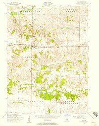
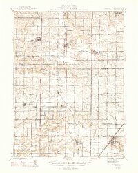
1953 Map of Viola
USGS Topo · Published 1957About this map
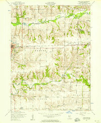
The village of Viola serves as a central hub on this mid-century survey, situated at the intersection of local commerce and the Chicago Burlington and Quincy railroad line. The surrounding rural landscape is deeply carved by the North Pope Creek and Pope Creek drainage systems, creating a pattern of upland farming interspersed with wooded draws. This era captures a classic Illinois prairie township structure, where family farms were still served by neighborhood institutions like the Green Summit School, Fairview School, and White Lily School. The abundance of small family and community burial grounds, such as St Johns Cemetery and Bridger Cemetery, provides significant data for genealogists tracing early Mercer County lineages. Smaller settlements like Gilchrist and Wanlock appear along the rail corridor, marking the importance of steam-era transportation in the local economy before the total dominance of regional highways.
Find a feature on this map
31 named features on this map. Tap any name to fly to it.
Don’t see what you’re looking for? This feature index may not catch every label — zoom into the map to look around manually.
Map Details
Editions of this 1953 Viola Map
2 editions found
Other maps of this area

1912 · Milan
USGS Topo · 1:62,500
1923 · Alexis
USGS Topo · 1:62,500
1925 · Alexis
USGS Topo · 1:62,500

1937 · Orion
USGS Topo · 1:62,500

1944 · Milan
USGS Topo · 1:62,500
1947 · Woodhull
USGS Topo · 1:62,500
1953 · Matherville
USGS Topo · 1:24,000
1953 · New Windsor
USGS Topo · 1:24,000
1953 · Orion
USGS Topo · 1:24,000
1953 · Aledo East
USGS Topo · 1:24,000