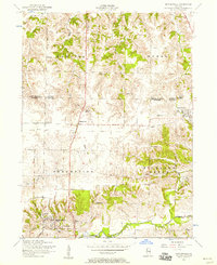
1953 Map of Matherville
USGS Topo · Published 1957About this map
Matherville and the southern edge of Sherrard anchor this mid-century landscape along the border of Rock Island and Mercer Counties. The terrain is defined by the winding valley of the Edwards River and the prominent Lake Matherville south of town. The area’s industrial heritage is clearly visible in the presence of the Gilhrist Mine (Abandoned) and Coal Valley Mine (Abandoned), which together with various segments of a Dismantled railroad, reflect a transition away from the region's earlier coal-mining economy.
Find a feature on this map
27 named features on this map. Tap any name to fly to it.
Don’t see what you’re looking for? This feature index may not catch every label — zoom into the map to look around manually.
Map Details
Editions of this 1953 Matherville Map
2 editions found
Other maps of this area

1912 · Milan
USGS Topo · 1:62,500

1923 · Alexis
USGS Topo · 1:62,500

1925 · Alexis
USGS Topo · 1:62,500

1937 · Orion
USGS Topo · 1:62,500

1944 · Milan
USGS Topo · 1:62,500

1947 · Woodhull
USGS Topo · 1:62,500
1948 · Milan
USGS Topo · 1:24,000

1949 · Coal Valley
USGS Topo · 1:24,000

1950 · Milan
USGS Topo · 1:24,000
1953 · Coal Valley
USGS Topo · 1:24,000