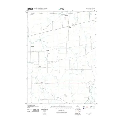
2010 Map of Alexander
USGS Topo · Published 2010About this map
Tonawanda Creek and its southern tributaries define the rural geography of western Genesee County on this 2010 survey. The landscape is characterized by a network of small agricultural hamlets and crossroads, including Alexander, Darien, and East Pembroke. The drainage patterns of Murder Creek and Bowen Creek illustrate the natural hydrology that shaped the original settlement of the region. Local heritage is preserved in several prominent burial grounds, such as Hillside Cemetery and Maple Hill Cemetery, which serve as vital landmarks for genealogical research in these small communities. The map also records the location of smaller stops and junctions like Lehigh, Griswold, and Sawens, reflecting a pattern of habitation rooted in the area's development. This edition provides an accurate baseline of the modern road network and waterways as they existed in the early 21st century.
Find a feature on this map
58 named features on this map. Tap any name to fly to it.
Don’t see what you’re looking for? This feature index may not catch every label — zoom into the map to look around manually.
Map Details
Editions of this 2010 Alexander Map
This is the sole edition of this map. No revisions or reprints were ever made.
Other maps of this area

1897 · Albion
USGS Topo · 1:62,500

1897 · Medina
USGS Topo · 1:62,500

1904 · Batavia
USGS Topo · 1:62,500

1905 · Attica
USGS Topo · 1:62,500

1944 · Alexander
USGS Topo · 1:31,680

1949 · Attica
USGS Topo · 1:62,500

1949 · Alexander
USGS Topo · 1:24,000
1949 · Akron
USGS Topo · 1:24,000

1949 · Cowlesville
USGS Topo · 1:24,000
1949 · Attica
USGS Topo · 1:24,000