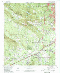
1986 Map of Alexander
USGS Topo · Published 1986About this map
Ellis Mountain and Alexander Mountain dominate this mid-1980s terrain where the western suburbs of Little Rock meet the Saline County line. The map records a landscape in transition, characterized by established rural communities like Martindale and Collegeville alongside growing residential developments such as Shannon Hills and Mabelvale. Local history is deeply etched into the topography through numerous family and community landmarks, including Martindale Ch, Quinn Chapel, and Crystal Hill Ch. Large memorial grounds like Forest Hills Memorial Park (Cemetery) and Pine Forest Memorial Park (Cemetery) serve as significant regional markers. Transport and industry are represented by the Missouri Pacific railroad corridor and several Quarries tucked into the slopes of Ellis Mountain, illustrating the area's dual role as a suburban retreat and a resource-rich upland.
Find a feature on this map
73 named features on this map. Tap any name to fly to it.
Don’t see what you’re looking for? This feature index may not catch every label — zoom into the map to look around manually.
Map Details
Editions of this 1986 Alexander Map
This is the sole edition of this map. No revisions or reprints were ever made.
Other maps of this area

1890 · Benton
USGS Topo · 1:125,000

1891 · Little Rock
USGS Topo · 1:125,000

1893 · Little Rock
USGS Topo · 1:125,000

1894 · Benton
USGS Topo · 1:125,000

1935 · Little Rock
USGS Topo · 1:24,000

1935 · North Little Rock
USGS Topo · 1:24,000

1935 · Alexander
USGS Topo · 1:48,000

1938 · Benton
USGS Topo · 1:48,000

1941 · Alexander
USGS Topo · 1:62,500

1943 · Pinnacle Mtn
USGS Topo · 1:31,680