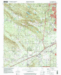
1994 Map of Alexander
USGS Topo · Published 2000About this map
Ellis Mountain and Alexander Mountain dominate the terrain west of the Little Rock corporate boundary, where suburban expansion meets the steep ridges of central Arkansas. In the mid-1990s, this area transitioned from the rural character of Martindale and Lawson to the more developed corridors along Stagecoach Road and Interstate 30. Significant local landmarks include Forest Hills Memorial Park (Cemetery) and the Baptist Medical Center, alongside established neighborhoods like Mabelvale and Terrytown. The map captures a landscape defined by its hydrology, where Fourche Creek and Otter Creek wind through the valleys between the mountains. For genealogists and local historians, the sheet is exceptionally rich in burial sites and small community centers, including Ida Mission Cem, Pleasant Grove Cem, and Quinn Chapel, providing a detailed view of the region's social geography during a period of steady growth.
Find a feature on this map
82 named features on this map. Tap any name to fly to it.
Don’t see what you’re looking for? This feature index may not catch every label — zoom into the map to look around manually.
Map Details
Editions of this 1994 Alexander Map
This is the sole edition of this map. No revisions or reprints were ever made.
Other maps of this area

1890 · Benton
USGS Topo · 1:125,000

1891 · Little Rock
USGS Topo · 1:125,000

1893 · Little Rock
USGS Topo · 1:125,000

1894 · Benton
USGS Topo · 1:125,000

1935 · Little Rock
USGS Topo · 1:24,000

1935 · North Little Rock
USGS Topo · 1:24,000

1935 · Alexander
USGS Topo · 1:48,000

1938 · Benton
USGS Topo · 1:48,000

1941 · Alexander
USGS Topo · 1:62,500

1943 · Pinnacle Mtn
USGS Topo · 1:31,680