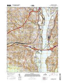
2016 Map of Alexandria
USGS Topo · Published 2016About this map
Arlington Heights and the surrounding urban corridors of Northern Virginia sit at a complex intersection of transportation and history along the Potomac River. This 2016 survey details the densely packed residential and commercial fabric of communities like Shirlington, Del Ray, and Glencarlyn. The landscape is notably punctuated by several small, historic burial sites that survive amidst modern development, including the Syphax Family Graveyard and the Deuterman Family Graveyard.
Find a feature on this map
170 named features on this map. Tap any name to fly to it.
Don’t see what you’re looking for? This feature index may not catch every label — zoom into the map to look around manually.
Map Details
Editions of this 2016 Alexandria Map
This is the sole edition of this map. No revisions or reprints were ever made.
Other maps of this area

1890 · Mt. Vernon
USGS Topo · 1:125,000

1891 · Mt. Vernon
USGS Topo · 1:125,000

1892 · Brandywine
USGS Topo · 1:62,500

1894 · Mt. Vernon
USGS Topo · 1:125,000

1895 · Brandywine
USGS Topo · 1:62,500

1897 · Mt. Vernon
USGS Topo · 1:125,000

1899 · Patuxent
USGS Topo · 1:125,000

1900 · Washington
USGS Topo · 1:62,500

1906 · Patuxent
USGS Topo · 1:125,000

1911 · Brandywine
USGS Topo · 1:62,500