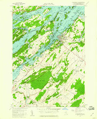
1958 Map of Alexandria Bay
USGS Topo · Published 1960About this map
Boldt Castle and the Sunken Rock Lighthouse dominate the riverfront at Alexandria Bay, marking the height of the mid-century Thousand Islands era. This survey, compiled from 1957 aerial photography, captures the intricate network of the St Lawrence River along the border with Canada. Large landmasses like Wellesley Island and Hill Island are mapped in detail, showing a mix of established state parks and private landmarks. Away from the tourist-heavy shoreline, the landscape transitions into the agricultural interior of Alexandria, where roads like Taylor Road and Otter Road connect small settlements such as Omar and Alexandria Center. Genealogists will find notable burial grounds including Riverside Cem and Omar Cem, while the inclusion of a Drive-in Theater near Collins Landing reflects the cultural expansion of the late 1950s.
Find a feature on this map
60 named features on this map. Tap any name to fly to it.
Don’t see what you’re looking for? This feature index may not catch every label — zoom into the map to look around manually.
Map Details
Editions of this 1958 Alexandria Bay Map
2 editions found
Other maps of this area

1900 · Clayton
USGS Topo · 1:62,500

1903 · Grindstone
USGS Topo · 1:62,500

1903 · Clayton
USGS Topo · 1:62,500

1903 · Alexandria Bay
USGS Topo · 1:62,500

1903 · Theresa
USGS Topo · 1:62,500

1942 · Clayton
USGS Topo · 1:24,000

1943 · Thousand Island Park
USGS Topo · 1:31,680

1943 · Redwood
USGS Topo · 1:31,680

1943 · Clayton
USGS Topo · 1:31,680

1943 · Lafargeville
USGS Topo · 1:31,680