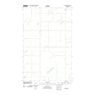
2011 Map of Alexandria
USGS Topo · Published 2011About this map
East Writing Rock Cemetery sits near the southwestern corner of this Divide County landscape, providing a primary point of reference for genealogists and local historians. The surrounding terrain is defined by the rigid grid of the Public Land Survey System, where north-south routes like 140th Ave NW and 138th Ave NW intersect east-west roads such as 100th St NW and 93rd St NW. This network facilitates travel across a prairie environment dotted with numerous small lakes and depressions characteristic of the region. County Hwy 3 serves as the central north-south thoroughfare, anchoring the rural transportation pattern at the start of the 21st century. The sparse distribution of named sites reflects the open, agricultural character of this corner of North Dakota.
Find a feature on this map
16 named features on this map. Tap any name to fly to it.
Don’t see what you’re looking for? This feature index may not catch every label — zoom into the map to look around manually.
Map Details
Editions of this 2011 Alexandria Map
This is the sole edition of this map. No revisions or reprints were ever made.
Other maps of this area

1948 · Smoky Butte
USGS Topo · 1:24,000

1948 · Stady
USGS Topo · 1:24,000

1953 · Williston
USGS Topo · 1:250,000

1957 · Williston
USGS Topo · 1:250,000

1983 · Colgan West
USGS Topo · 1:24,000

1983 · Writing Rock North
USGS Topo · 1:24,000

1983 · Alexandria
USGS Topo · 1:24,000

1983 · Writing Rock South
USGS Topo · 1:24,000
1983 · Fortuna
USGS Topo · 1:24,000
1983 · Colgan East
USGS Topo · 1:24,000