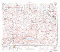
1957 Map of Williston
USGS Topo · Published 1957About this map
The Missouri River winds along the southern edge of this survey, marking a stark contrast to the high, prairie pothole landscape of the northwestern corner of North Dakota. This mid-century view captures a region defined by its international border with Canada and a dense network of early 20th-century rail lines. The Great Northern and Minneapolis St Paul and Sault Ste Marie railroads serve as the primary conduits for grain and commerce, connecting agricultural hubs like Williston, Crosby, and Kenmare. Extensive natural resource extraction is evident in the coal strip mines near Noonan and Larson, while the conservation efforts of the era are reflected in the broad boundaries of the Lostwood National Wildlife Refuge and Shell Lake National Wildlife Refuge. The map details many small prairie settlements, including Wildrose, Flaxton, and Grenora, during a time of post-war stabilization.
Find a feature on this map
112 named features on this map. Tap any name to fly to it.
Don’t see what you’re looking for? This feature index may not catch every label — zoom into the map to look around manually.
Map Details
Editions of this 1957 Williston Map
This is the sole edition of this map. No revisions or reprints were ever made.
Historical Maps of Williston Through Time
3 maps found