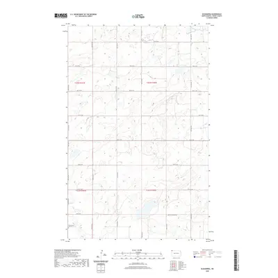
2020 Map of Alexandria
USGS Topo · Published 2020About this map
The Township of Alexandria presents a stark and rhythmic landscape of the North Dakota prairie, defined by a rectilinear grid of section lines and gravel roads. In the southwest corner, the East Writing Rock Cem serves as a critical point of interest for genealogists tracing early families in this corner of Divide County. The terrain is dotted with numerous small wetlands and potholes characteristic of the glaciated plains, with Rattler Lake standing out in the northwest. This 2020 edition documents the persistent agricultural structure of the region, where township and range lines like t162n r101w and t161n r101w organize the vast, open acreage into manageable parcels for dryland farming.
Find a feature on this map
15 named features on this map. Tap any name to fly to it.
Don’t see what you’re looking for? This feature index may not catch every label — zoom into the map to look around manually.
Map Details
Editions of this 2020 Alexandria Map
This is the sole edition of this map. No revisions or reprints were ever made.
Other maps of this area

1948 · Smoky Butte
USGS Topo · 1:24,000

1948 · Stady
USGS Topo · 1:24,000

1953 · Williston
USGS Topo · 1:250,000

1957 · Williston
USGS Topo · 1:250,000

1983 · Colgan West
USGS Topo · 1:24,000

1983 · Writing Rock North
USGS Topo · 1:24,000

1983 · Alexandria
USGS Topo · 1:24,000

1983 · Writing Rock South
USGS Topo · 1:24,000
1983 · Fortuna
USGS Topo · 1:24,000
1983 · Colgan East
USGS Topo · 1:24,000