
Loading...
Loading map...2023 Map of Alexandria
USGS Topo · Published 2023About this map
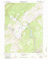
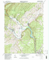
The confluence of the Frankstown Branch Juniata River and the Little Juniata River forms the central geography of this Huntingdon County corridor. The borough of Alexandria is flanked by several significant burial sites, including the Alexandria Methodist Cem and Alexandria Presbyterian Cem, while the historic Old Hartslog Cem is situated to the north. These early religious and community centers were established near the water gaps through Tussey Mountain and Warrior Ridge.
Find a feature on this map
43 named features on this map. Tap any name to fly to it.
Don’t see what you’re looking for? This feature index may not catch every label — zoom into the map to look around manually.
Map Details
Date Portrayed2023
Date Published2023
PublisherU.S. Geological Survey
Map TypeTopographic
Scale1:24000
Physical Dimensions24 x 29 inches
Editions of this 2023 Alexandria Map
This is the sole edition of this map. No revisions or reprints were ever made.
Historical Maps of Warrior Ridge Through Time
3 maps found
Featured Locations
Source Details
SourceU.S. Geological Survey
CopyrightPublic Domain